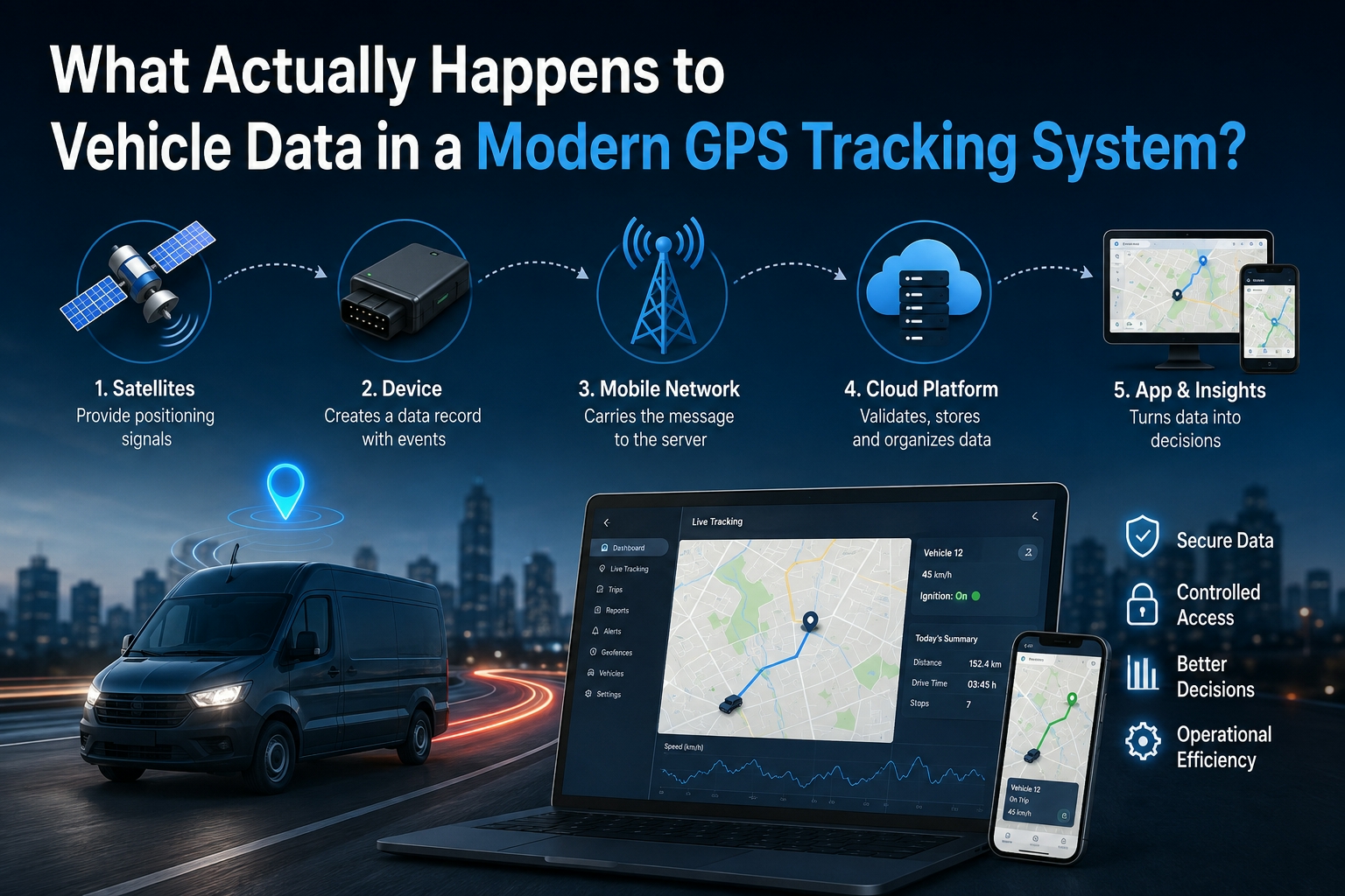
A vehicle-tracking screen looks deceptively simple. A map opens, a marker appears and the user can see where a car, van or truck is located. Behind that marker is a continuous exchange between satellites, the tracking device, a mobile network, cloud software and the user’s phone or computer.
Understanding that flow helps buyers compare systems more intelligently. It also helps fleet managers establish sensible rules for security, data access and retention. A tracker is not merely a locator. It is a small connected computer that turns raw signals into operational information.
Stage one: satellites provide positioning signals
Global Navigation Satellite Systems transmit precise timing information from orbit. A tracker receives signals from multiple satellites and calculates its position by measuring how long those signals took to arrive. More satellite signals and a clear view of the sky generally improve the calculation.
Tall buildings, covered parking, tunnels and dense structures can temporarily affect satellite reception. This does not necessarily mean the tracker has failed. It may retain its last reliable position until it can calculate a new one.
The satellites do not usually send the location to the owner’s phone. They help the device determine where it is. A second communications layer is needed to move that information to the tracking platform.
Stage two: the device creates a data record
The tracking unit combines location with other information available from the installation. Depending on the hardware and configuration, a record may include time, speed, heading, ignition state, power status and an event code.
An event code tells the platform why a record was generated. It might represent a scheduled update, an ignition change, movement outside a geofence, overspeeding or a power interruption. This approach is more useful than treating every message as identical because the platform can prioritise important events and organise them for reporting.
Devices also need a strategy for temporary network outages. A capable unit can retain records in local memory and send them after connectivity returns. Buyers should ask how much data can be stored, which events are preserved and how delayed records are displayed. That behaviour is particularly important for vehicles travelling through regional areas.
Stage three: the mobile network carries the message
Most connected vehicle trackers contain a SIM and use a mobile network to transmit data. Satellite coverage and mobile coverage are separate issues: the device may know its position even when it cannot immediately send that position to the server.
Network selection therefore needs to reflect the operating area. A business working within metropolitan districts may prioritise price and reliable urban service. A fleet covering regional routes may place more weight on wider network availability. The decision should be based on real routes rather than a general assumption that one configuration suits every driver.
An Australian GPS tracking platform can simplify this arrangement by packaging the device, SIM, app access and support into one service. That removes several integration tasks, but buyers should still understand which network is supplied and what occurs when the vehicle enters an area without coverage.
Stage four: cloud software validates and stores data
The receiving server identifies the device, validates the message and places the information into a secure data store. The application then converts technical fields into human-readable events, trips, stops, alerts and reports.
This stage is where software quality becomes visible. Two systems can use comparable hardware yet deliver very different experiences. A useful platform groups records into complete journeys, distinguishes a stop from a loss of signal and presents timestamps consistently. Poorly designed software may overwhelm users with raw points or create misleading gaps.
Storage also enables trip playback and historical analysis. A manager can review where a vehicle travelled, how long it stopped and whether an alert occurred during the route. That record can support scheduling, customer-service reviews and maintenance planning, but it should always be interpreted in context.
Stage five: the app turns records into decisions
The mobile or web app is the user’s main contact with the system. It requests authorised data from the platform and displays the latest position, recent trips and configured alerts.
Good interface design is not cosmetic. A business may need to find a vehicle during an urgent event, and a driver or office administrator should not have to navigate a maze of settings. Clear labels, sensible defaults and responsive performance determine whether the system becomes part of daily operations.
Reports should also answer practical questions. Examples include distance travelled, time spent idling, repeated after-hours movement and the number of visits to a location. Reports are most useful when a manager begins with a question and selects the smallest amount of data needed to answer it.
Protecting accounts and location information
Location data deserves careful handling because it can reveal routines, customer addresses and business activity. Organisations should use unique passwords, restrict access to people who need it and remove accounts promptly when roles change. Multi-factor authentication should be enabled when available.
Shared logins make access harder to audit. Individual user accounts with appropriate permission levels provide better control. A dispatcher may need current locations, while an external contractor may need only a temporary shared tracking link.
Businesses should also document how tracking is used. Employees need to understand the purpose of the system, the vehicles it covers and who can review historical records. Legal requirements vary across Australia, so organisations should obtain appropriate advice before introducing workplace monitoring.
Device choice changes the data context
A plug-in OBD tracker is quick to install and can often be moved between compatible vehicles. That flexibility suits personal cars, rental operations and small fleets, although the device may be accessible if someone knows where to look.
A hardwired tracker is installed more discreetly and remains with the vehicle. It can suit fleets, trucks and high-value work vehicles where permanent power and resistance to casual removal are priorities. Professional installation may be appropriate to ensure safe connections and correct placement.
Before comparing vehicle tracking plans, a buyer should decide whether portability or permanence is more important. Subscription price is only one part of the calculation. Installation, network choice, support, data access and the useful life of the device all affect the real cost.
From coordinates to operational knowledge
The greatest value in a tracking system comes from the full chain working reliably. Satellites support positioning, the device records events, the mobile network transports them, the platform organises them and the app presents them to an authorised user.
Every link in that chain can shape the result. A clear understanding of the process helps businesses ask better questions, choose appropriate hardware and build responsible policies. The dot on the map is only the final visual expression of a much larger data system.